Home
Aviation Stories
"In Memory Of"
Net Sites
Sign Guestbook
View Guestbook
Email Ron
Sell your Trust Deed

Geoglyphs of the SW DesertReprinted from the Mar-Aprl 2003 issue of Southwest Aviator Magazine (page 62).
Southwest AviatorStory and Photos
By Ron KilberWednesday, January 22, 2003
A few years after Charles Lindbergh flew his Spirit of St. Louis from New York to France, another pilot flying along the Colorado River first noticed giant drawings on the desert floor north of Blythe, California. One of the earth figures measured 176 feet in length. Since then, more than two-hundred images have been discovered along the river from Nevada to the Gulf of California. All told, six-hundred-plus geoglyphs have been recorded in the Southwest and nearby areas of Mexico.
Known also as intaglio, it's not known if geoglyphs are two-hundred years old or ten thousand. These giant ground paintings depict geometric designs, human form and animal figures. Many have withstood the test of wind, rain and time, others having fallen recent victim to motorcycles, SUV's, quads and General George S. Patton's tank-training exercises during WWII.
Geoglyphs were made by carving away the darker top layer of rock in the moonscape desert, revealing a lighter sand and subsurface. The difference in color and relief produce distinct images that scientists can't agree on age. Some argue they were made one- to two-hundred years ago, while others think they've been around since before the calendar changed from B.C. to A.D.
It's believed intaglios were made by ancestors of today's Native Americans living along the Colorado River. Perhaps the drawings are messages to their gods or ancestors, a common theme throughout human civilization. It's unlikely the graphics served other purpose because you can't discern most from the ground without knowing exactly what to look for. Even from a nearby hilltop, distance and angle make viewing nearly impossible. From an airplane, you'll fly circles for hours unless you know the precise location of a geoglyph. They're just hard to find, but easy to see once located.
Some geoglyphs depict what might be a horse. If so, this means some intaglios are recent in history because Native Americans didn't come into contact with equestrian animals until introduced by the Europeans after Columbus discovered America.
Geoglyphs are classified as rock art, which also includes pictographs and petroglyphs. Pictographs are rock paintings while petroglyphs are rock engravings. Pictographs are generally found in coastal mountain ranges while petroglyphs are more often found in the desert. Intaglios are often located near the Colorado River.
To understand the meaning of geoglyphs, an observer must be familiar with the complex and sophisticated symbolism of Native American culture. There are multiple interpretations of not only earth drawings but all rock art. It depends on who you consult. Native Americans have their own version, much of which is spiritually based. On the other hand, there are archeologists who prefer mythical interpretation. Religious scholars are able to see in geoglyphs ancient themes that appear not only in North American cultures, but in other cultures around the globe. But the bottom line is that all intaglios provide a unique window into Native American rituals, beliefs, and artistic abilities.
The Internet has been providing new glimpse and interpretation of rock art. With thousands of amateur and professional archaeologists sharing discoveries online, they've found some Native American rock-art symbolism that is identical to that found in other parts of the world. This means ancient people from other cultures must have migrated here thousands of years ago (or vice versa).
Most interesting are those experts who find geoglyph interpretation that parallels myth and legend found in all of humanity, suggesting that all cultures on earth had origin from a single, common influence. New sholars are pursing the study of sacred, ancient mysteries and the way these stories appear to be repeating themselves not only in other cultures but in our own time. The origin of Christianity, for example, contains ancient, hidden iconography, which some experts use to suggest that contemporay myths are really the same as those from bygone cultures and time.
Given the huge volume of rock art worldwide, one thing seems apparent: rock-art sites were as plentiful then as are churches today. Expression was important and widespread, the same as is religious worship today. And rock art expresssion must have been as sacred for them as religion is for people today.
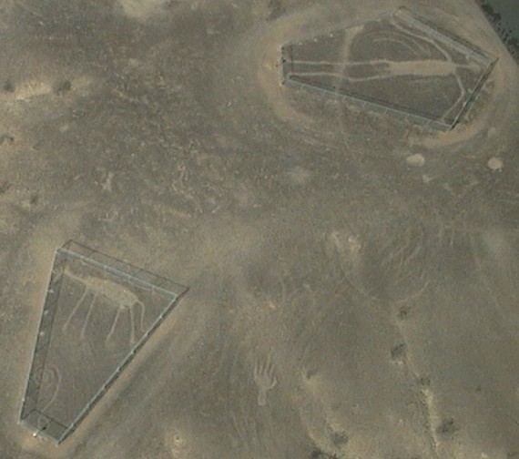
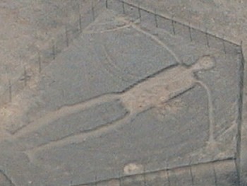
The Blythe Intaglios.
Ironically, the Blythe Intaglios site -- discovered first -- is now considered by experts to contain the most well known of all Southwestern desert drawings. They're located approximately 15 miles north of Blythe, California, just west of the highway running along side the Colorado River. There are six distinct figures in three locations that are within approximately 1,000 feet of each other.
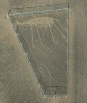
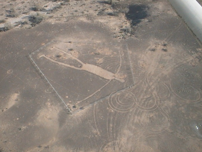
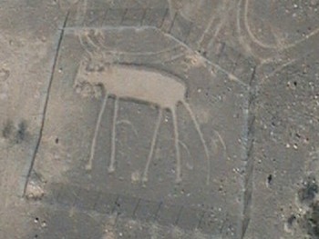
An animal figure believed to be a horse or mountain lion, with a geometric design under.
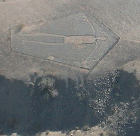
Blythe Intaglios. This figures measures 171 feet from head to toe. Notice the damage caused by tires.
Click photo for high-resolution image
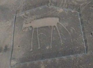
Blythe Intaglios. The fence arrived too late to prevent tire damage.
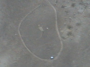
Blythe Intaglios.
Click photo for high-resolution image
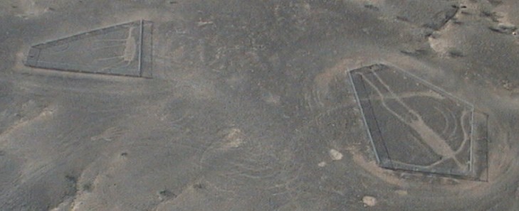
Blythe Intaglios.
Click photo for high-resolution image
Blythe Intaglios.
Blythe Intaglios.
Click photo for high-resolution image
Blythe Intaglios.Flying over geoglyphs requires caution. The Blythe Intaglios site elevation is about 500' MSL, but terrain rises rapidly to the west with mountains in the immediate vicinity. The popularity of the site means another airplane and pilot might show at any time for a close-in look. A normal-lens camera requires flying low to get a good photograph. Compounded with steep turns while peeking through the viewfinder, the risk is very real for controlled flight into terrain. When in a group, it's best to take turns photographing while other aircraft circle overhead or nearby. It's also best to have a skilled pilot at the controls while you take pictures.
Without GPS capability, the best way to locate the Blythe Intaglios is by finding the Aha Quin Airport, which is on the sectional chart about 20 miles north of Blythe right on the Colorado River. Follow the water south a few miles to a point where homes dot the shore line. From there, go west a short distance to a group of small mesas with a network of dirt roads going seemingly nowhere. The geoglyphs can easily be viewed when at 500' AGL. (GPS coordinates: N33 48 00.0 - W114 32 00.0)
The Fisherman
The Fisherman intaglio depicts a man suspending a spear, with two fish shown below, a sun and serpent above. This geoglyph is located in the foothills of the Plomosa Mountains on the paved road from Bouse to Quartzsite. You can't find the Fisherman without first finding the dirt road that leads you to it. Because this intaglio is small, it's hard to spot even when directly overhead. The dirt road begins on the inside curve of the highway just before it turns westward and descends from the mountain range onto rugged desert plains. Rising terrain is in all quadrants except to the west towards open desert. (GPS coordinates: N33 47 27.9 - W114 05 37.2)
The Fisherman near Bouse, ArizonaThere isn't agreement on who made the Fisherman. Some experts argue that native Americans carved it; others claim it is the workings of a sculptor who made it sometime around the 1930's (not long after the first intaglio was discovered). There's probably no way to know for sure, given that some scientific dating techniques used are still considered experimental.
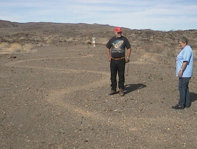
The Snake
The Snake is located about 10 miles east of Parker on Shea Road (paved road leading north and east of town), near a T intersection with a dirt road that leads south. The site isn't but 1,000 feet southeast of this corner, convenient for anyone who wants to hike after landing on the paved road, which is suitable for light-plane landing. There's a convenient parking area on the southwest corner of the intersection. Watch for road signs and motor traffic. The geoglyph lies atop a dark-colored terrace devoid of vegetation. (GPS coordinates: N34 07 26.3 - W114 04 26.0)
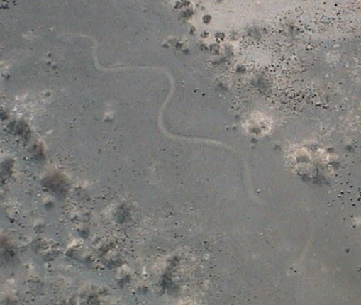
The Snake.
Observe closely to see the eyes, which are in the extreme lower right of the photo.
Click photo for high-resolution image
Click photo for high-resolution imagePerhaps geoglyphs are just another variation on art form. Most intaglios are found near the Colorado River. Wherever man has found a plentiful and reliable food source, he has ended up with a surplus of time on his hands. Time translates into artistic expression. This is common occurrence throughout the history of civilization. British Columbian native inhabitants, for example, spent only a few minutes each day fishing the incredibly rich waters of the Northwest. The remainder time was used to create beautifully crafted totem poles. Few other cultures produced more art per capita. Their counterparts in harsher environments, for example, produced comparatively little art.
Like D.B. Cooper, the time of origin of these giant earth drawings remains a mystery. One thing about geoglyphs is certain: Just as one lone pilot discovered the Blythe Intaglios during Charles Lindbergh days, many more await discovery by sharp-eyed pilots.
Places to Land
Viewing geoglyphs takes time, especially when circling to take pictures or waiting while others in your group fly in for a closer look. This, coupled with a long commute, means you might need fuel and food.
The Avi Suquilla Airport (P20) at Parker, Ariz., has a 4,800-foot, hard-surface runway. The airport is owned and operated by the Colorado River Indian Tribes. Jet A and 100 LL are available seven days a week, generally 8 a.m. to 5 p.m. The tribe provides free shuttle service to your destination, including their Blue Water Casino, which is on the river less than a mile from the airport, providing a food buffet for breakfast, lunch and dinner.
The airport at Blythe, Calif. (BLH), has a good, hard-surface runway (length 6,500 feet). Before landing, look for the truck stop on the east end of the field, then taxi and park in an area that is less than a 1,000-foot hike to the restaurant.
In Arizona, the towns of Quartzsite and Bouse offer dirt strips, however, neither is recommended for pilots unfamiliar with the areas. Flash floods can destroy a field in a matter of minutes, making safe landing impossible until the road grader repairs the damage.
Copyright 2003 Ron Kilber All rights reserved
###
Copyright (C) 2003 Ron Kilber rpknet@aztecfreenet.org RonKilber.tripod.com You may reprint this story for non-commercial use provided this copyright notice is left intact. Permission will not be unreasonably withheld for all other uses.