Home
Aviation Stories
"In Memory Of"
Net Sites
Sign Guestbook
View Guestbook
Email Ron
Sell your Trust Deed

Harquahala Peak ObservatoryThe Indian Hills Airpark Association Great Dune Buggy Outing
By Ron Kilber
Saturday, April 22, 2000
Like so much of life, there are problems associated with any lifestyle. Take airpark living, for example. A pilot can only fly an airplane so much, and when the spring wind blows like it does here in Arizona's Outback country, well, there are other things (of course, not necessarily better) that one can do besides risking to bend in the wind man's favorite invention -- the airplane.
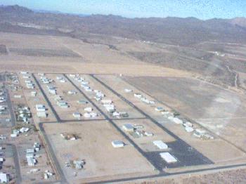
Indian Hills Airpark, Salome, AZ
Photo: Suzanne HongToday, I'm fortunate to have an invitation to ride along on one of the association's favorite alternative pass-times -- dune-buggying in Arizona's own Outback country. In perfect skies and 70-degree air, I'm copiloting in the right seat of neighbor Bob Bumgardner's Great Red Dune Buggy Machine (GRDBM), first a Volkswagen, now a modified dune buggy capable of negotiating some of God's worst terrain here in the great Sonoran Desert of the Southwest.
Joining us are 18 other IHAA flying enthusiasts and members, traveling in eight additional off-road vehicles. Led by fellow-IHAA member and Alaska snowbird, Howard Smith, Bob and I are in the middle of a dune-buggy caravan heading easterly on the Salome Highway from Salome, Arizona. Our caravan is pretty much dominating the road for a good half-mile-long stretch. Anyone wishing to pass would need a long open space or would need to cross over the yellow center-line (not at all uncommon here in Arizona).
Our destination is the now closed, near-six-thousand-foot-high Harquahala Peak Observatory, two hours or so -- forever, without an off-road vehicle -- from the Indian Hills Airpark. Most member vehicles are equipped with citizens-band radios (CB), so we're able to stay in touch with each other to know if someone should break down. Traveling this way provides peace-of-mind not otherwise attainable on one's own, motivating to go where otherwise discouraged alone.
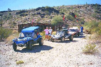
Tire-check break
Photo: Suzanne HongAt the turn-off to Aguila, we make a left turn in Bumgardner's GRDBM until we reach the unimproved road leading northward towards the observatory and the summit of the Harquahala Mountains. Within a short distance, there are new rest-room facilities -- a bit sore thumbish way out here in the middle of nowhere. Perhaps an in-trouble politician was forced to make good on a campaign promise, and a pit stop is the best s/he could do. At any rate, the females among us get their money's worth while us guys prefer the natural cover of nearby palo verde trees.
Resuming our trek, we negotiate the serpentine, up-and--down trail through lush, more-than-usual green desert, and where it's too high for the Saguaro cacti to survive -- perhaps 4,500 feet above sea level -- not all dune buggies can, either. It's too steep for John and Suzanne Hong's buggy, forcing Bob and I to take up observatory position while we wait for them to retreat from a failed attempt on a steep and slippery portion of this back-country roadway. Once they turn around and come back down -- wheels locked and skidding, dust blowing -- Bob and I take their place, succeeding with the GRDBM to join four other vehicles already summit-bound.
Thanks to CB radios, our fearless leader out front knows to turn around, retreating towards the Hongs to render aid with a tow rope and his stronger buggy.
After Bob and I pull over for another palo-verde break, Smith roars by our GRDBM -- effortlessly -- uphill with the Hongs in quiet tow behind. Bob and I agree it's pretty much a shoe-in that everyone will make it to the summit today -- provided Smith's eagerness to tow doesn't wane.
Before Bob and I resume on the dusty trail, here comes another vehicle in tow. This time it's Den Peck's four-wheel-drive Bronco towing his wife Teddy's two-wheel-drive buggy. They're my next-door neighbors, too, splitting up today so that Ernie and Vera Wright, buggy-less like me, can join the caravan.
Surprising to both Bob and me, the vehicle appearing to have the least prospects for negotiating the 25-percent difficult grade is the Flintmobile. It makes it's way slow and steady like no buggy has before. Belonging to IHAA members Ed and Betty Haynes, it's a pink, home-made contraption with a car-top carrier large enough for two people to sleep in. A great way to keep heat-seeking rattle snakes out of your sleeping bag at night.
Once we all reach the summit, naturally, it's pic-nic time. No one is more eager for lunch than Mary Ann, the flying dog. Mary Ann belongs to Tom and Rose Washburn, Indian Hills' original developers. Mary Ann loves to copilot Tom's airplane, thus, the flying-dog moniker.
Afterwards, curiosity leads me to the nearby Harquahala Peak Observatory. The small corrugated-metal facility is all boarded up with a chain-link fence around it. A weather-worn plaque states the observatory sits at an elevation of 5,688 feet and was built in 1920 by the Smithsonian Astrophysical Observatory For Solar Research. It also says this place is listed in the National Record for Historic Places.
Also on the summit is a communications-antennae complex with a security fence monitored by closed-circuit TV cameras. A wind sock and heliport, no doubt, provide air access for maintenance crews.
The view from the summit is 360-degree fantastic. Looking east, it's easy to see the White Tank Mountains, perhaps 60 miles on the horizon in the direction of Phoenix. The Eagle Tail Mountains with its Court House Rock are easily discernible to the south. Looking west, the Indian Hills Airpark is visible, too. North lies Alamo Lake, however, it's not visible due either to haze or a mountain range. On a much clearer day, this mountain-top summit would offer hundred-mile and more views in every direction.
Descending the mountain is more dangerous, in my view, than climbing. No where is it more important to control speed than on an hair-pin corner on the way down. Too fast, and you risk going over the edge on an outside turn. Some canyons are one-thousand feet to the bottom, making survivability extremely unlikely when going off the roadway. And there are no guard rails for the hapless to rely upon.
By late afternoon, Bob, I and the GRDBM return, together with everyone else, safely back at the Indian Hills Airpark. What a great day it's been. And what a great way to spend a day -- with fun neighbors and friends.
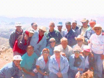
Group at Summit Of Harquahala Peak
Photo: Suzanne HongToday's participants:
Bob "RV-6" Bumgardner & Ron Kilber
Howard & Marjorie "Mooney" Smith
Den & Teddy "Piper J-3" Peck
Ernie & Vera "Luscombe" Wright
Tom & Rose "C-182" Washburn (and flying-dog Mary Ann)
John & Suzanne "Glasair" Hong
Art & Pinkey "Twin-Comanche" Anderson
Ron & Marge "E-35" Skites
Ed & Betty "C-182/Flintmobile" Haynes
Norm & Carol "C-182" McAdams
Dennis & Karen HildrethCopyright (C) 2000 Ron Kilber rpknet@aztec.asu.edu RonKilber.tripod.com Non-commercial reproduction permitted in its entirety with this copyright notice intact.
Revised 8/13/2000